The Pacific Northwest is bracing for an extraordinary meteorological event that has the makings of a decadal phenomenon. With forecasts indicating a staggering accumulation of snow reaching up to five feet in the Cascades, the region is on the cusp of what could be a defining moment in its weather history.
Key Takeaways
- The frontal system impacting the Pacific NW has the potential for intense storm intensity and heavy precipitation, particularly in the Cascade Mountains.
- The combination of cold air and mountain ranges can amplify storm intensity and lead to significant snowfall.
- The forecast models, particularly the European model, predict significant snow accumulation in the region.
- There is also concern about a subtropical storm evolving into a bomb cyclone, with strong winds and potential coastal impact, highlighting the need for assessment and mitigation measures.
Frontal System Impact Analysis
As the frontal system advances, you’ll observe cold air cumulus clouds trailing behind, signaling the imminent mountain snowfall and the intricate interplay with the region’s topography. This phenomenon is a direct result of cold air interaction with the warmer, moist air ahead of the system. The clashing air masses lead to precipitation patterns that are heavily influenced by the mountainous terrain, effectively wringing out moisture as the system climbs in elevation.
Understanding frontal system dynamics is crucial as they dictate storm intensity. When a dense, cold air mass pushes into a warmer, humid one, it forces the warm air upward, leading to the cooling of this air and condensation into clouds. Temperature fluctuations play a vital role in determining the type of precipitation, with colder temperatures resulting in snow rather than rain.
In the coming days, more snowfall is expected as the frontal system persists. However, the exact trajectory of the cold air remains uncertain. This unpredictability can significantly affect local weather conditions. If the cold air moves more slowly or takes a different path, precipitation amounts and storm impacts could vary widely.
The interaction between the moving cold air and the stationary mountain ranges can amplify storm intensity, resulting in heavy snowfall. This process, known as orographic lift, can cause localized areas to experience significantly more snow than surrounding regions. Additionally, the frontal system can lead to strong gusty winds, which, when combined with heavy snowfall, can create hazardous conditions.
Therefore, as you monitor the weather, pay close attention to updates on the frontal system’s progress and prepare for a range of outcomes due to the complex nature of these weather events.
Mountain Snow and Wind Advisory
You should brace for significant disruptions as the approaching storm system is forecasted to deposit up to 5 feet of snow on the Cascade Mountains, accompanied by strong gusty winds. This heavy mountain snowfall is the result of a robust frontal system interacting with the orographic features of the range, enhancing precipitation through a process known as orographic lift. The National Weather Service has highlighted the Cascades in their latest advisories, indicating the potential for an extreme snow event.

As cold air cumulus clouds trail the frontal boundary, lower snow levels are anticipated next week, further complicating travel and residential conditions. Wind gusts, potentially reaching damaging speeds, are expected to coincide with this significant snowfall, creating a dual threat that could lead to widespread travel disruptions and power outages. The combination of heavy snow loads and high winds poses a substantial risk to infrastructure, including the likelihood of downed trees and power lines.
With Spokane, Washington, preparing for multiple rounds of storms, residents and travelers in the region must remain vigilant. The current forecast models suggest a period of instability, with a weaker system arriving on Monday, followed by a stronger one on Tuesday. This progression could result in a continuous impact on the region, reducing the window for recovery between events.
For those of you in the affected areas, it’s critical to monitor updates from local weather services and plan accordingly. Precautions should include preparing for potential power outages and having an emergency kit ready. If travel is necessary, expect delays and dangerous conditions, and always check the latest road reports before departing. Stay informed, stay safe, and remember that winter weather in the Pacific Northwest can be both unpredictable and severe.
Forecast Model Predictions
Forecast model predictions indicate a period of showery air trailing the frontal system, with Oregon expecting continued residual showers. As you delve into the scientific data, it’s evident that forecast accuracy is paramount in predicting the course of these dynamic weather events. The European model, known for its detailed analysis of atmospheric conditions, is projecting significant snow accumulation. What this means for you is that you should be prepared for not just a dusting of snow but potentially a substantial layer, especially in higher elevations.
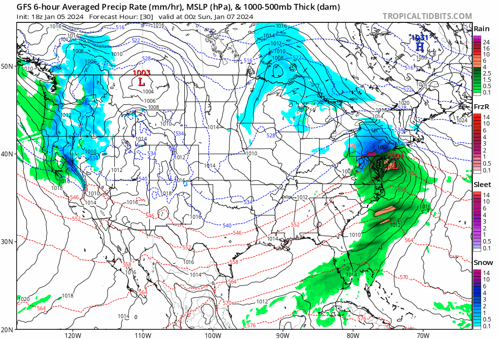
The upcoming weather systems are subject to rapid changes in temperature fluctuations, which can alter the storm intensity quite significantly. Early in the week, a weaker system is anticipated to pass through, but don’t let your guard down, as this is merely a prelude to a stronger system slated to arrive on Tuesday. This second wave carries with it not only moisture but instability that could result in lightning strikes—a rare but hazardous winter weather phenomenon.
Precipitation patterns are not uniform across the region. While some areas may experience a steady, soaking rain, others, particularly in the Cascade Mountains highlighted by the National Weather Service, should brace for heavy snowfall. These patterns are influenced by the interplay between the incoming systems and the existing atmospheric conditions, including the trajectory of the colder air flowing from the north.
Subtropical Storm Evolution
Emerging from the subtropics, the storm system is rapidly expanding into a powerful low-pressure area with the potential to escalate into a bomb cyclone, exhibiting strong winds and significant coastal impact. As you analyze the subtropical storm formation, you’ll notice that the system’s origin is characterized by a blend of warm and cooler air masses, a typical hallmark of such disturbances. This hybrid nature contributes to the unpredictability in storm track analysis, influencing both trajectory and speed as it moves toward the Pacific Northwest.
When assessing storm intensity, meteorologists rely on various models that consider atmospheric pressure drops, wind speed increases, and the thermal structure of the storm. The steep pressure gradient is a clear indicator of intense winds that can lead to extensive damage in coastal communities. You’re tracking a system that could rapidly intensify, a phenomenon known as bombogenesis, which is marked by a drop in atmospheric pressure of at least 24 millibars in 24 hours.
Your focus is not solely on the winds but also on the storm surge potential, a critical concern for low-lying areas. The surge, compounded by high tides and waves, can lead to severe flooding and erosion, disrupting lives and livelihoods. Hence, it’s imperative to evaluate the coastal impact, factoring in local topography and population density to predict and mitigate potential harm.
As this powerful storm approaches, it’s crucial to stay informed and prepared. Keep an eye on updates from local weather authorities and understand that the situation may change rapidly, requiring prompt action to ensure safety.
Arctic Influence on Weather Dynamics
As we monitor the subtropical storm’s development, it’s equally crucial to consider the Arctic High’s progression across British Columbia and Alberta, which introduces new variables to the weather dynamics in the Pacific Northwest. This Arctic High is pivotal; it’s set to interact with the subtropical system, potentially altering weather patterns significantly.

The presence of the Arctic High leads to a sharp temperature drop as it funnels cold air southward. This drop is vital to understanding the atmospheric conditions that will affect the region. The cold front associated with the Arctic High can instigate cyclogenesis, creating the potential for a dynamic winter storm. As the cold front sweeps through, it’s likely to clash with the warmer, moist air from the subtropical storm, intensifying precipitation and possibly leading to heavy snowfall, especially in the mountainous regions.
Forecast models, particularly the European model, are suggesting lower snow levels, indicative of the Arctic air’s influence. It’s crucial to track the trajectory of this cold air because its path will dictate the extent of the cold front’s reach and the severity of the temperature drop. Moreover, the jet stream’s position and strength will either amplify or diminish the impact of these converging systems.
Uncertainty still looms regarding the precise movement of the Arctic air. Cyclogenesis could lead to a dynamic winter storm if conditions align. As you watch for updates, keep an eye on these factors—the Arctic High’s movement, the jet stream’s behavior, and the interaction between the cold front and the subtropical moisture. These elements will together define the unfolding weather events in the Pacific Northwest.